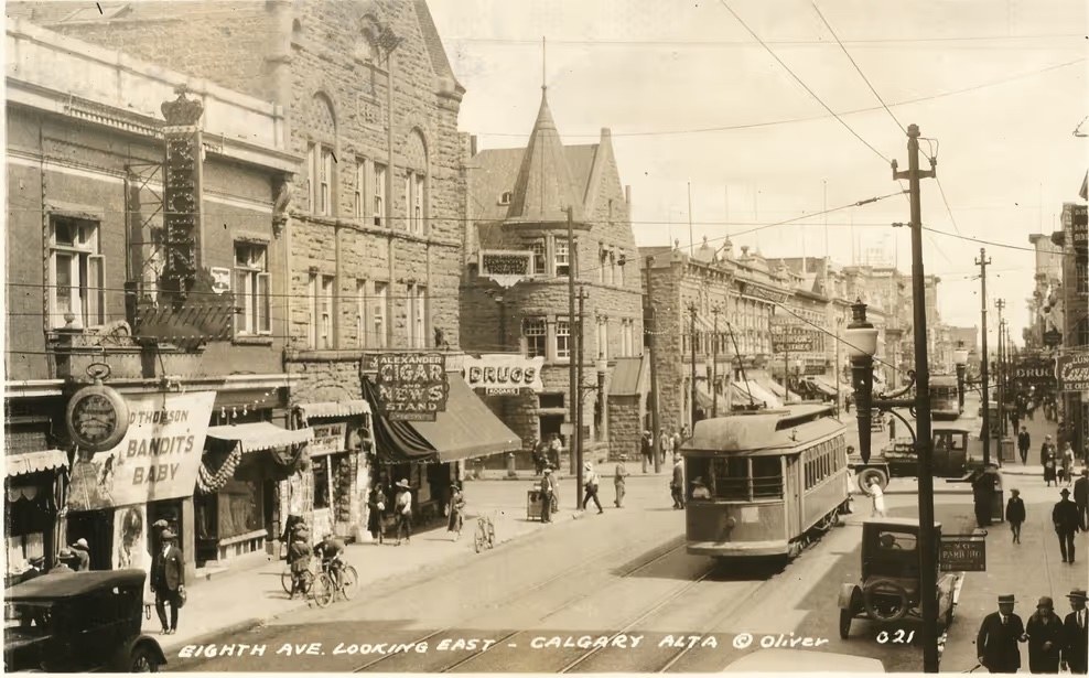
A short history
- Long before 1875: The Blackfoot call the meeting of the Bow and Elbow rivers Mohkinstsis. It was a gathering place for thousands of years before any fort.
- 1875: The North West Mounted Police build a post at the confluence. First called Fort Brisebois, it is renamed Fort Calgary in 1876, after Calgary on Scotland's Isle of Mull.
- 1877: Treaty 7 is signed at Blackfoot Crossing by the Siksika, Kainai, Piikani, Tsuut'ina and Stoney Nakoda nations.
- 1883: The Canadian Pacific Railway arrives. It builds its station on its own land west of the Elbow, and the town follows it there instead of staying around the fort in what is now Inglewood.
- 1884: Calgary becomes the first incorporated town in what is now Alberta. It becomes a city on January 1, 1894.
- 1886: A fire destroys about 18 buildings on what is now 9th Avenue. Afterward the city pushes builders toward local Paskapoo sandstone, and Calgary earns the name Sandstone City.
- 1912: Guy Weadick stages the first Calgary Stampede, backed by four ranchers known as the Big Four: Pat Burns, George Lane, A.E. Cross and Archibald McLean.
- 1914: Dingman No. 1 strikes wet gas at Turner Valley, and Calgary's first oil boom begins. After Leduc No. 1 in 1947, Calgary becomes the head office city for Canada's oil and gas industry.
- 1968: The Husky Tower opens. It is renamed the Calgary Tower in 1971.
- 1988: Calgary hosts the XV Olympic Winter Games, February 13 to 28.
- 2013: The Bow and Elbow flood in June, and about 75,000 people leave their homes, the largest evacuation in the city's history.
Historic neighbourhoods
Many of these neighbourhoods still have the boulevards planted under William Reader, the city's parks superintendent from 1913 to 1942. The City counts 27 of them as historic streetscapes, and you'll find the best of them under each neighbourhood below.
Southeast · Founded 1875 as East Calgary · Calgary's oldest neighbourhood
Inglewood
Calgary started here. Ninth Avenue, once Atlantic Avenue, was the city's first main street, and the neighbourhood takes its name from Colonel James Walker's homestead. A.E. Cross opened the Calgary Brewing & Malting Company in 1892, and the riverside became known as Brewery Flats. In 2014 the Canadian Institute of Planners named Inglewood Canada's Greatest Community.
Pro tip: Walk 9th Avenue and look up. Many of the storefronts are in buildings from the early 1900s.
Historic streets: Beyond the 9th Avenue storefronts, the block of 9 Ave SE between 21 and 22 St SE still has the poplars planted in 1930.
Southwest · Subdivided 1906 · Once called American Hill
Mount Royal
The upper hill was nicknamed American Hill for the wealthy Americans who built there. The CPR renamed it Mount Royal, after Montreal, home of CPR president William Van Horne, and laid out curving, garden-suburb streets for some of the city's grandest homes. It is still one of Calgary's most prestigious addresses.
Historic streets: Royal Avenue and Prospect Avenue are where the early mansions went up, including the Sayre Estate (1905) and the Jamieson Residence (1909) on Royal and the R.B. Bennett House (1912) on Prospect. In upper Mount Royal, Frontenac, Montcalm, Montreal and Quebec curve along the hill under boulevards of elm and green ash planted in 1929 and 1930.
Southwest · Founded 1875 · Once the Village of Rouleauville
Mission
Oblate missionaries founded the Mission of Notre Dame de la Paix here in 1875, and Father Lacombe laid out the townsite in 1884. The French Catholic village of Rouleauville incorporated in 1899 and joined Calgary in 1907. Rouleau House (1885) and the old Holy Cross Hospital (1892) still stand, and St. Mary's Cathedral anchors the neighbourhood.
Southwest · First homes 1909 · River-bend suburb
Elbow Park
Developer Freddy Lowes laid it out as an exclusive suburb along the Elbow River, and the first houses went up in 1909, his own among them. Its residents' association, founded in 1930, is said to be the oldest community association in the city.
Historic streets: Garden Crescent SW, planted in 1911, was the first streetscape in Calgary to be designated historic. Riverdale Avenue SW still has the elms and honeysuckle planted in 1929, between 9 and 10 St SW and again from 5A St to Elbow Drive, and Sifton Boulevard keeps its 1929 green ash.
Southwest · Planned 1909 to 1910 · An Olmsted design
Scarboro
Calgary's first picturesque suburb. The CPR hired John Charles Olmsted of the Olmsted Brothers, the firm founded by Central Park's designer, to plan it, and lots sold in the 1912 boom. Streets curve with the hilltop instead of following the grid, little triangle parklets sit at the intersections, and the original rules called for 30-foot setbacks and single-family homes only. It is one of only three fully built Olmsted-designed suburbs in Canada, and the parks and boulevards are still largely as planned.
Pro tip: Walk the 200 block of Scarboro Avenue, a run of houses from 1912 to 1914, then find Triangle Park, the only one of Scarboro's park plots still in its original form.
Historic streets: Shelbourne Street (1927), Senlac Street and Sharon Avenue (both 1930) keep their original boulevard plantings of lilac, cotoneaster and poplar.
Southwest · Annexed 1906 to 1912 · CPR worker housing
Cliff Bungalow
Once CPR land, with modest homes for railway workers on the slopes above the Elbow. Many of its early 1900s homes survive, and the name became official in 1970.
Historic streets: 5A Street SW, from 17th Avenue to Royal Avenue, has the oldest of the city's historic boulevards, planted with green ash in 1915.
Southwest · Annexed 1907 · Riverside enclave
Rideau Park and Roxboro
Two small, leafy enclaves on the Elbow. Roxboro was subdivided in 1912, and building took off again in the 1920s. Look for the 1915 Mission Bridge and Lindsay's Castle, an unfinished sandstone house.
Inner city · Victoria Park and Connaught · Named for a streetcar
Beltline
The name comes from Route 5 of the Calgary Municipal Railway, the streetcar line that looped through here and was called the belt line. Connaught and Victoria Park were joined as one community in 2003. Victoria Park takes its name from the fairgrounds, named for Queen Victoria in 1889, which grew into the Stampede grounds.
Northwest · Settled in the 1880s · First neighbourhood north of the Bow
Hillhurst and Sunnyside
The first residential area across the river. Senator Matthew Cochrane named Hillhurst after his family farm in Quebec, and in 1904 Ezra Riley donated the land for Riley Park.
Historic streets: The lilac medians on 11 St NW (1919), 6 Ave NW and Bowness Road NW (both from 1929 to 1932) were planted to carry Riley Park's garden feel into the streets. Walk them when the lilacs bloom.
Northeast · Village of Riverside 1903 · Immigrant roots
Bridgeland-Riverside
Riverside became a village in 1903 and was informally called Germantown, while the CPR developed Bridgeland for working families. The Calgary General Hospital opened here in 1910, and the old 1,000-bed hospital was imploded in 1998.
Historic streets: 8 St NE, from 1st to 5th Avenue, was planted in 1942 with elms, lilac and dogwood, the last of the city's historic boulevards.
Southeast · Settled in the 1880s · Along the Old North Trail
Ramsay
Spiller Road follows part of the Old North Trail, an ancient Indigenous trade route, and Scotsman's Hill above the neighbourhood was once a sandstone quarry. The streets are lined with Edwardian and Queen Anne Revival homes, and streetcars crossed the Macdonald Bridge from 1911.
Historic streets: 9 St SE, from 17th Avenue to Adelaide Street, keeps its 1929 boulevard of green ash, lilac and honeysuckle.
Northwest · Village 1908 · Annexed 1910
Crescent Heights
Lots went on sale in 1906, the village formed in 1908 and Calgary annexed it in 1910, with streetcars the following year. Calgary's first branch library opened here in 1913. The bluff along Crescent Road still has one of the best views of the skyline.
Historic streets: 7th to 11th Avenues, between Centre Street and 2nd Street, have boulevards planted from 1929 to 1932, many still with their original stamped sidewalks.
Northwest · Subdivided 1911 · Its own town until 1964
Bowness
John Hextall registered the first Bowness subdivision plans in 1911. It became a village in 1948 and a town in 1952, and only joined Calgary in 1964. Bowness Park's lagoon has been a summer and winter tradition for generations.
Southwest · Built 1952 to 1956 · A royal postwar suburb
Britannia
The name goes back to a 1911 plan, but the community was built in the 1950s, with Britannia Drive, Coronation Drive, Crown Avenue and Imperial Way honouring the monarchy. Queen Elizabeth II toured the neighbourhood in 1959, and it was the first Calgary community built with underground wiring.
Southwest · Annexed 1910 · Named for a theatre and a streetcar loop
Altadore and Marda Loop
Altadore was annexed and named in 1910, and Currie Barracks grew next door from the 1930s. Marda Loop, a name from the mid-1980s, combines the Marda Theatre, opened in 1952 by Marc and Mada Jenkins, with the old No. 7 streetcar loop that ran here from 1913 to 1948.
Historic homes
Lougheed House, Deane House and Hunt House are under Landmarks. The rest are still standing, and a few you can walk right into for dinner. Homes marked private are lived in today, so admire them from the sidewalk.
Inglewood · Built 1891 · Now Rouge restaurant
A.E. Cross House
A.E. Cross, the brewer and one of the Stampede's Big Four, bought this house in 1899, and his family lived here for decades. One of Calgary's oldest homes, with a widow's walk, a sandstone foundation and gingerbread trim.
Pro tip: Book dinner at Rouge to see inside.
Fish Creek Park · Built 1896 · Now a restaurant
Bow Valley Ranche House
Rancher William Roper Hull built it for about $4,000, and Pat Burns bought it in 1902 and added a games room, tennis court and pool. It sat empty for years before a community group saved it, and the full restoration was finished in 2014.
Beltline · Built 1896 to 1901 · Community and arts hub
McHugh House
A rare buff-brick Queen Anne Revival house built for rancher J.J. McHugh, and one of the last buildings left from French Rouleauville. In 2014 it was moved a block north to save it.
Mission · Built 1885
Rouleau House
Owned from 1887 by Dr. Édouard Rouleau, whose family gave Rouleauville its name. It has been moved twice, and the City saved it from demolition in 2003.
Inglewood · Built 1910
Colonel Walker House
The third house Colonel James Walker built on his homestead, the one that gave Inglewood its name. It sits inside the bird sanctuary, an easy stop on a walk.
Mount Royal · Built 1911 · Private home
Coste House
Built for Eugene Coste, a pioneer of Canada's natural gas industry, and one of the grandest estates on the hill.
Mount Royal · Built 1905 · Private home
Sayre Estate
Built for A. Judson Sayre, whose company bought CPR land and brought many of the American settlers who gave American Hill its nickname.
Mount Royal · Built 1909 · Private home
Jamieson Residence
Home of Reuben Jamieson, mayor of Calgary from 1908 to 1910. His wife Alice went on to become one of the first women judges in the British Empire.
Mount Royal · Built 1912 · Private home
Dick House
A.A. Dick and his new wife survived the sinking of the Titanic on their way home from their honeymoon in Europe, and came home to this house.
Mount Royal · Built 1912 · Private home
R.B. Bennett House
The future prime minister bought it in 1920, though it seems he never lived here.
Scarboro · Built 1912 · Private home
Wallace Residence
A turreted Queen Anne Revival house built by contractor and former alderman Milton Ross Wallace, who also built its neighbour at 228.
Scarboro · Built 1914 · Private home
J. Frank Moodie Residence
Home of J. Frank Moodie, a self-taught geologist who helped develop the Drumheller coal fields and Turner Valley oil.
Scarboro · Built 1931 · Private home
George Edworthy Residence
Built for George Edworthy, later president of the Calgary Exhibition and Stampede in 1952 and 1953.
Landmarks
Downtown · Free
Stephen Avenue National Historic Site
Named for CPR president George Stephen, and a National Historic Site since 2002 for its run of nearly three dozen buildings from 1880 to 1930. Many are the sandstone blocks built after the 1886 fire.
Pro tip: Look above the shop windows. The carved sandstone and the original building names are all still there.
Inglewood · Where Calgary began
Fort Calgary and Hunt House
The site of the 1875 fort at the confluence, now a historic site and museum. Next door, Hunt House is a Hudson's Bay Company log cabin from about 1876 to 1881, the oldest building in Calgary still on its original spot.
Inglewood
Deane House
Built in 1906 for Superintendent Richard Burton Deane, the commanding officer at Fort Calgary. In 1929 it was moved across the Elbow to where it stands today.
Beltline · Built 1891
Lougheed House
Senator James and Isabella Lougheed called their sandstone mansion Beaulieu, "beautiful place," and it was the centre of Calgary society for decades. Today it is a museum with formal gardens that are free to wander.
Pro tip: Come in summer for the gardens, then take the house tour.
Downtown · Opened 1914
Fairmont Palliser
The CPR's grand railway hotel opened on June 1, 1914, without a formal ceremony. After a 1929 addition it was Calgary's tallest building until 1958.
Downtown · Built 1907 to 1911
Historic City Hall
A Romanesque Revival sandstone landmark with a clock tower, designed by William M. Dodd of Regina. It has been a National Historic Site since 1984.
Downtown to Crescent Heights · Built 1916
Centre Street Bridge
The bridge opened in 1916, and its lions followed in 1917, sculpted by city labourer James L. Thompson after the lions in London's Trafalgar Square. The lions on it today are recast copies of the originals.
Downtown · Built 1912 to 1913
Burns Building
Built for Pat Burns, the meat-packing magnate and one of the Stampede's Big Four. Its cream terra cotta facade faces Olympic Plaza.
Downtown · Opened 1913
The Hudson's Bay Building
A cream terra cotta department store that opened in August 1913. The colonnade over the 8th Avenue sidewalk was added in 1930.
Beltline · Opened 1912
Memorial Park Library
Alberta's first public library building, funded mostly by Andrew Carnegie. It sits in Central Memorial Park, which began as a tree nursery and has had a cenotaph since 1928.
Downtown · Built 1930 to 1931
Calgary Public Building
Calgary's main post office until 1961. Its elevators are the last known attendant-operated passenger elevators in Alberta.
Downtown · About 1910
The Grain Exchange
Built for rancher William Roper Hull, and Calgary's first reinforced concrete high-rise. It also had the city's first passenger elevator.
Downtown West · Built 1917 to 1918
Mewata Armoury
A Tudor Gothic armoury that looks like a castle on the edge of downtown, and still in military use today.
Erlton · Free
Reader Rock Garden
The hillside garden of William Reader, the city's parks superintendent from 1913 to 1942. It became a National Historic Site in 2018.
Pro tip: It's free, and an easy walk from the Stampede grounds.
Mission · Completed 1957
St. Mary's Cathedral
The current cathedral, in the heart of the old Catholic mission, replaced an 1889 sandstone church.
Also see: Heritage Park, Stephen Avenue Walk and The Confluence on the See and Do page.